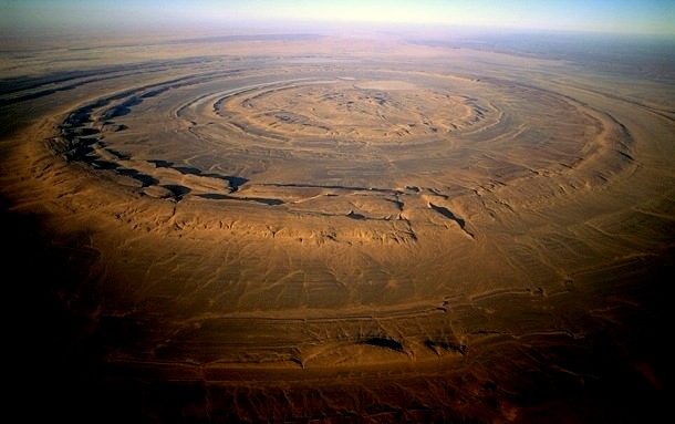
The Eye of the Sahara: A Cosmic Bullseye Hiding the Secrets of Atlantis?
There are places on this Earth that defy explanation. Places that whisper of a time long forgotten, of a history scrubbed from the books. And deep in the desolate expanse of the Mauritanian desert, there is a scar on the face of our planet so strange, so perfect, that it has fueled a firestorm of controversy for decades.
They call it the Richat Structure. But online, among truth-seekers and modern-day explorers, it has another name: The Eye of the Sahara.
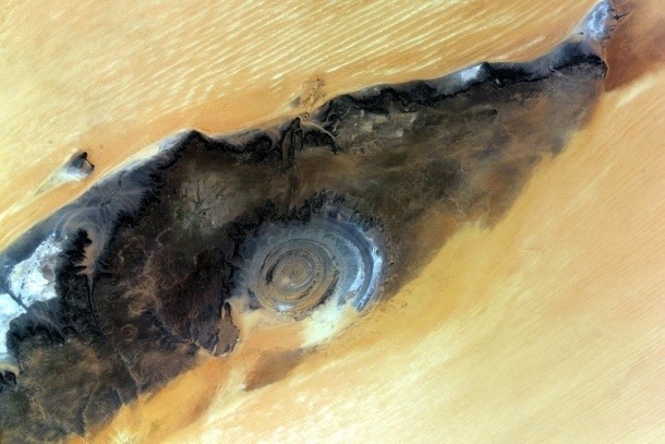
A perfect, 25-mile-wide set of concentric rings. A geological bullseye staring up into the heavens. It’s so massive, so distinct, that it became a crucial landmark for astronauts on the very first space missions. A cosmic waypoint in an ocean of sand.
But what is it?
The official story is… convenient. Boring, even. But the other possibilities? They will shake the very foundations of what you think you know about human history.
Look at that image. Does that look natural to you? Some say this is the impact site of a crashed UFO. The final, sandy grave of a vessel that fell from the stars millennia ago. Others whisper a more tantalizing theory. A theory that connects this strange circle to the greatest legend of all time.
Atlantis.
What “They” Want You to Believe: The Official Story
Before we journey down the rabbit hole, let’s get the textbook explanation out of the way. It’s the story you’ll find on Wikipedia, the one geology professors will tell you with a straight face.
They say the Richat Structure is a “domed anticline.” A mouthful, right? Basically, they believe a massive bubble of molten rock pushed its way up from deep within the Earth, creating a huge, blister-like dome. But it never quite broke through the surface. It just sat there, for maybe 100 million years.
Then, over eons, the relentless desert wind and sand acted like a giant piece of sandpaper. It scrubbed the top of the dome clean off, layer by layer. Because the dome was made of different kinds of rock—some hard, some soft—they eroded at different speeds. The hard quartzite rock resisted the erosion, forming the high ridges you see as rings. The softer sedimentary rock was carved away, creating the valleys between them.
So, the story goes: it’s just a coincidence. A geological freak show. Nothing more than a happy accident of rock, time, and wind.
But does that feel right to you? A perfect circle, 25 miles wide, with evenly spaced rings? An accident?
It’s too neat. Too tidy. And when things are this perfect in nature, it’s often because they aren’t natural at all.
The UFO Connection: A Scar on the Earth
One of the earliest and most persistent theories is that the Eye is not a geological formation, but an impact crater. Not from a meteor—the ground is too flat, and there’s no evidence of shocked quartz associated with typical impacts. No, this theory points to something far more exotic.
A ship.
Imagine a colossal mothership, disabled and spiraling out of control, careening through our atmosphere thousands of years ago. It slams into the soft earth of what was then a lush, green Sahara. The impact is catastrophic, creating concentric shockwaves that ripple through the ground, flash-fossilizing the terrain into the rings we see today. The central dome? That could be the remnants of the craft itself, buried deep beneath the sand, its power source long dead.
The Evidence for an Alien Crash
Proponents of this idea point to several anomalies:
- The Sheer Scale: The energy required to create such a massive and defined structure is immense. A controlled, or uncontrolled, landing of a craft using unknown propulsion systems could easily leave such a mark.
- The Circularity: Unlike messy meteor impacts, the crash of a disc-shaped or cylindrical craft could plausibly create a more uniform, circular depression with distinct rings representing different parts of the ship or energy fields collapsing.
* Local Legends? While specific, documented local myths about a “ship from the sky” in this exact region are hard to pin down, North Africa is rich with stories of sky gods and fiery chariots. Could these be the faded memories of a real event, passed down through generations as myth?
It’s a mind-bending thought. Are we looking at the tombstone of visitors from another world? A cosmic Roswell hidden in plain sight, so large and so old that no one thought to question it? It’s a compelling idea. But it’s not even the wildest one.
Deep Dive: Plato’s Blueprint for a Lost City
This is where everything changes. In recent years, with the advent of satellite imagery on platforms like Google Earth, everyday people have been able to scrutinize our planet’s surface like never before. And what they found in the Richat Structure has sent shockwaves through the alternative history community.
It’s a perfect match. A dead ringer. For Plato’s Atlantis.
Forget everything you think you know about Atlantis. Forget the underwater city from cartoons. Let’s go back to the source: the Greek philosopher Plato, writing around 360 B.C. in his dialogues *Timaeus* and *Critias*. He wasn’t writing fiction; he was documenting a story passed down through his family from the great Athenian statesman Solon, who in turn heard it from Egyptian priests.
This was history. And Plato gave us a very, very specific blueprint.
The Checklist from Critias
Plato described the capital city of Atlantis in stunning detail. Let’s break it down, point by point, and see how it stacks up against the Eye of the Sahara.
1. Concentric Rings of Land and Water: Plato is explicit. He states Atlantis was made of a central island, surrounded by a ring of water, then a ring of land, another ring of water, and another ring of land. Three rings of water, two of land, plus the central island.
Now look at the Richat Structure. The ridges and valleys form a near-perfect system of concentric rings. The valleys would have held the water, and the ridges the land. The central “island” is right there. It’s a stunning visual match.

2. The Dimensions: This is where it gets spooky. Plato provides measurements for the city in “stadia.” While the exact length of a stadion is debated, a common estimate is around 607 feet. When you do the math, Plato’s total diameter for the capital city of Atlantis comes out to about 127 stadia, or roughly 23.5 kilometers (14.6 miles).
The diameter of the inner rings of the Richat Structure? Almost exactly 23.5 kilometers. It’s a jaw-dropping coincidence, if that’s what it is.
3. An Opening to the Sea: Plato says a great canal was cut to the south, connecting the city’s rings to the ocean. Satellite and hydrological maps of the Richat Structure clearly show features that look exactly like ancient riverbeds or canals flowing from the rings southward. Exactly where Plato said it would be.
4. Mountains to the North: The story goes that Atlantis was sheltered by mountains to the north, which protected it from the harsh north wind. And what do we find just north of the Richat Structure? A massive mountain range, the Adrar Plateau, which would have offered a perfect shield.
But Wait, Atlantis was in the Ocean, Right?
This is the biggest hurdle for most people. “Atlantis sank beneath the waves.” But did it?
Plato describes a cataclysm of “earthquakes and floods” that destroyed Atlantis in a single day and night. The Richat Structure is currently about 1,300 feet (400 meters) above sea level. How could it have been a seaport?
Two explosive possibilities:
First, the “African Humid Period.” Scientists know that as recently as 5,000 to 11,000 years ago, the Sahara was not a desert. It was a green, lush savannah with massive lakes and rivers. A vibrant ecosystem. It was a completely different world. The location was not always an inhospitable wasteland.
Second, catastrophic geological upheaval. An event like the Younger Dryas impact theory—a proposed comet strike around 12,800 years ago—could have caused unimaginable earthquakes and tsunamis. Such an event could easily have caused massive crustal displacement, lifting the entire region of land thousands of feet in the air while simultaneously triggering the floods that wiped the city clean. The city wouldn’t have sunk; the land itself would have risen.
Suddenly, the legend of a city vanishing isn’t about sinking into the sea, but about being wiped off the map by a planetary-scale disaster that changed the very elevation of the continent.
The Final Questions That Demand Answers
If the Eye of the Sahara is indeed Atlantis, it forces us to ask some deeply uncomfortable questions. Why isn’t this the most famous archaeological site on Earth? Why aren’t teams from every major university crawling all over it?
The official answer is that a few geological surveys have been done, and they found no definitive proof of a city. But have they really looked? Or did they just look for what they expected to find—ancient stone—and ignore the rest?
What if the buildings weren’t made of stone that would last, but materials we can’t even comprehend? What if the real ruins are buried deep beneath the sand, undisturbed for 12,000 years?
The evidence is circumstantial, for now. But the coincidences are piling up. Too many to ignore.
A structure visible from space. A perfect match for Plato’s blueprint. The right dimensions. The right geography. The right location for a once-green Sahara.
So, what is the Eye of the Sahara? Is it a geological anomaly, a one-in-a-billion fluke of erosion? Is it the tomb of an alien craft, a secret held by the desert for millennia? Or is it the most important discovery in human history, hiding in plain sight? The last ghost of Atlantis, the mother-culture of all civilization, waiting for us to finally see what’s been staring us in the face all along.
The answers are out there, buried under the sand. The only question is, are we brave enough to start digging?