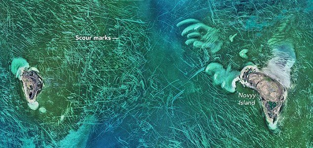
The image focuses on the area around Novyy Island.
A chaotic pattern of scour marks in the Tyuleniy Archipelago has been photographed by a NASA satellite.
First noticed by scientists at NASA’s Goddard Space Flight Center last month, the peculiar lines criss-crossing the world’s largest inland body of water have proven rather perplexing.
Captured using the Operational Land Imager on the Landsat 8 satellite, the photograph shows an area of the Caspian Sea that looks like it has been scoured using a Brillo Pad.
The water in this region of the Caspian Sea is actually very shallow – only around 10ft deep – and sea ice on the surface is also relatively thin at around 1.6ft thick.
Over time the winds and ocean currents can sculpt this ice in to jagged patterns known as hummocks which can sometimes reach as far as the seabed.
From 438 miles (705 kilometers) up, the floor of the north Caspian Sea looks like someone’s just scoured it with a Brillo Pad. What could these bizarre marks be? Trawling scars? Propeller marks in sea algae or seagrass? An extraterrestrial message?
Don’t get out the tinfoil hat yet: NASA scientists say these mystery lines are the work of sea ice.
NASA Goddard Space Flight Center ocean scientists noticed the image this month, shortly after it was acquired by the Operational Land Imager on the Landsat 8 satellite, according to NASA’s Earth Observatory. The space agency put out the puzzler on Twitter, asking readers what the lines might be.
– See more at: http://www.livescience.com/54554-mystery-lines-in-caspian-sea-satellite-image.html#sthash.5YNuM5Sy.dpuf
When the wind blows this floating ice around on the surface, the protruding parts underneath can drag along the ocean floor and create the line patterns seen in the satellite image.
Originally posted 2016-05-04 22:00:33. Republished by Blog Post Promoter

