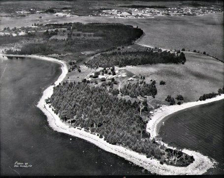
Oak Island is a 140-acre (57 ha) island in Lunenburg County on the south shore of Nova Scotia, Canada. The tree-covered island is one of about 360 small islands in Mahone Bay and rises to a maximum of 35 feet (11 m) above sea level. Located 200 metres from shore and connected to the mainland by a modern causeway, the island is privately owned, and advance permission is required for any visitation.
Oak Island is noted as the location of the so-called Money Pit and the site of over 200 years of treasure hunting.[1] Repeated excavations have reported layers of apparently man-made artifacts as deep as 31 metres (102 ft), but ended in collapsed excavations and flooding. Critics argue that there is no treasure and that the pit is a natural phenomenon, likely a sinkhole.
There are many 19th-century accounts of Oak Island, but some are conflicting and/or are not impartial.[2] Further, physical evidence from the initial excavations is absent or has been lost. A basic summary of the history of the pit is as follows:
In 1795, 18-year-old Daniel McGinnis, after observing lights coming from the island, discovered a circular depression in a clearing on the southeastern end of the island. Adjacent to the clearing was a tree with a tackle block on one of its overhanging branches.[3] Daniel McGinnis, with the help of friends John Smith (in early accounts, Samuel Ball) and Anthony Vaughan, excavated the depression and discovered a layer of flagstones a few feet below. On the pit walls there were visible markings from a pick. As they dug down they discovered layers of logs at about every 10 feet (3.0 m). They abandoned the excavation at 30 feet (9.1 m).[3]
This initial discovery and excavation was first briefly mentioned in print in the Liverpool Transcript in October 1856. A more complete account followed, again in the Liverpool Transcript,[3][4] the Novascotian,[5][6] British Colonist,[7] and A History Of Lunenburg County[8] (the last source based on the Liverpool Transcript articles).
About eight years after the 1795 dig, according to the original articles and the memories of Vaughan, another company examined what was to become known as the “Money Pit.” The Onslow Company sailed 300 nautical miles (560 km) from central Nova Scotia near Truro to Oak Island with the goal of recovering what they believed to be secret treasure. They continued the excavation down to approximately 90 feet (27.43 m) and found layers of logs or “marks” about every ten feet (3 m) and layers of charcoal, putty and coconut fibre at 40, 50 and 60 feet (12, 15 and 18 m ).
According to one of the earliest written accounts, at 80–90 feet (24–27 m), they recovered a large stone bearing an inscription of symbols.[4] Several researchers apparently attempted to decipher the symbols. One translated them as saying: “forty feet below, two million pounds lie buried.” The symbols currently associated with the “forty feet down…” translation and seen in many books first appeared in True Tales of Buried Treasure, written by explorer and historian Edward Rowe Snow in 1951. In this book he states he was given this set of symbols by Reverend A.T. Kempton of Cambridge, Massachusetts.[9] Nothing more is known about Kempton’s involvement in the Oak Island tale. The pit subsequently flooded up to the 33-foot (10 m) level. Bailing did not reduce the water level, and the excavation was abandoned.
Investors formed The Truro Company in 1849, which re-excavated the shaft back down to the 86 feet (26 m) level, where it flooded again. They then drilled into the ground below the bottom of the shaft. According to the nineteenth-century account, the drill or “pod auger” passed through a spruce platform at 98 feet (30 m), a 12-inch (300 mm) head space, 22 inches (560 mm) of what was described as “metal in pieces”, 8 inches (200 mm) of oak, another 22 inches (560 mm) of metal, 4 inches (100 mm) of oak, another spruce layer, and finally into clay for 7 feet (2.1 m) without striking anything else.

![oak_island[1]](https://coolinterestingnews.com/wp-content/uploads/2013/03/oak_island1.jpg)


