The Lost Archives: Can You Solve the Century-Old Mysteries Hidden in These Ghostly Aerial Photos?
Picture this. A dusty archive. Shelves groaning under the weight of history. Not books, but boxes. Thousands of them. And inside, not paper, but glass. Fragile, heavy glass plates, each one holding a ghost.
A ghost of a Britain that no longer exists.
These aren’t just old photographs. They are a secret history, captured from the sky by daredevil pilots, many of them veterans of the first great war in the sky. They flew in sputtering biplanes, wrestling with cameras the size of engine blocks, to capture a god’s-eye view of the world below. They documented everything. The birth of suburbs. The scars of industry. The quiet, winding lanes of villages that would soon be swallowed by motorways. They saw it all.
But time is the ultimate thief. Records were lost. Labels faded. Pilots forgot. Now, thousands of these incredible images are orphans—portraits without a name, landscapes without a location. They are mysteries etched in silver nitrate, floating in a digital void.
And that’s where you come in. An unprecedented rescue mission was launched to save these decaying snapshots from oblivion. Now, the call has gone out. To you. To me. To anyone with a keen eye and a love for a good puzzle. The archivists have hit a wall. They need a new kind of detective.
They need the internet.
A Treasure on the Brink of Extinction
The story begins with a company called Aerofilms. Founded in 1919 by men who had learned their trade in the deadly skies over the Western Front, it was a pioneering venture. These weren’t just photographers; they were aviators, map-makers, and spies. They took the skills they’d honed for war and turned them toward peace, creating a stunning visual record of a nation in flux.
For decades, they built an archive of over a million images. A staggering Domesday Book of the 20th century, seen from above.
But the physical collection was dying. The early photographs were captured on glass-plate negatives. Heavy. Brittle. Unstable. Over the years, the delicate emulsion began to peel, to crack, to succomb to vinegar syndrome—a slow, irreversible chemical decay that smells like its namesake and eats images alive. A single drop, a careless bump, a shift in humidity… and a town, a moment, a memory could be wiped from existence. Forever.
By 2007, the company itself was in trouble. The entire archive, this irreplaceable national treasure, was at risk of being broken up, sold off, or simply lost to ruin. It was a cultural emergency.
The Rescue Mission of the Century
In a race against time, a coalition of heroes stepped in. English Heritage, alongside the Royal Commissions on the Ancient and Historical Monuments of Scotland and Wales, acquired the entire Aerofilms Collection for the nation. It was a monumental undertaking.
Their mission: to pull these images back from the brink. They embarked on a painstaking process of conservation and digitization. Each glass plate had to be carefully cleaned, stabilized, and scanned in ultra-high resolution. It was archaeological work, but their dig site was a chemical emulsion just microns thick.
The result was the “Britain from Above” project. A breathtaking online portal designed to give this lost history back to the people it belonged to. They saved the images. But they couldn’t save their identities. That part of the mission was just beginning.
From the Cockpit to the Cloud: The Dawn of a New Perspective
It’s easy to forget how revolutionary these images were. Today, we have Google Earth in our pockets. We can zoom in on any street corner on the planet from a coffee shop. But in 1920? Seeing your town from the air was like looking at a photograph from Mars. It was science fiction made real.
These early aerial photographers were true pioneers. Think about the conditions.
No GPS. No pressurized cabins. They were flying in open-cockpit planes, exposed to biting winds and freezing temperatures. Their navigation was done with a map, a compass, and a good look at the ground. They had to fly low and steady, all while operating a camera that was a clunky, mechanical beast. Sometimes, taking a single picture required the pilot to bank the plane sharply while the photographer leaned out of the cockpit, wrestling the camera against the wind, his fingers numb with cold.
Every photo was an act of daring.

A Legacy of War
This wasn’t just a commercial enterprise. The very concept of aerial photography was forged in the crucible of World War I. For the first time, generals could see behind enemy lines. They could map trenches, spot troop movements, and identify artillery positions. The camera in the sky became a weapon as powerful as any gun.
The men who founded Aerofilms were masters of this new art of aerial intelligence. When the war ended, they brought that military precision to civilian life. But did they leave the world of secrets behind entirely?
Looking through the archive, you start to wonder. They weren’t just taking pictures of cathedrals and country houses. They were documenting infrastructure. Ports. Factories. Railway junctions. Power stations. The very bones of the nation. In the nervous years between the two World Wars, was this purely for commercial interest? Or was someone, somewhere, keeping a strategic record, just in case?
The Unidentified Files: When History Loses Its Address
Of the first batch of tens of thousands of images uploaded to the Britain from Above website, a huge number were labeled simply “unidentified.”
How does that even happen? Logbooks go missing. Pilots making numerous flights in a single day might mislabel a canister of film. A simple clerical error a century ago could orphan an image today. The result is a collection of ghost towns and phantom landscapes. We can see them with perfect clarity, but we have no idea where they are.
Look again at that first photograph. What do you see? A substantial town, nestled in a river valley. A large, multi-arched bridge dominates the foreground. Terraced houses climb the hills. In the distance, the smoke of industry. It’s so specific. It feels so real. Someone lived in those houses. Someone crossed that bridge every day to go to work.
But where is it? Is it in Wales? The north of England? Scotland? The clues are there, hiding in plain sight. The architecture of the buildings. The design of the bridge. The shape of the hills. To an archivist in an office, it’s an anonymous location. But to someone who grew up there? To someone whose great-grandfather laid the bricks for that factory? It’s home.
This is the core of the mystery. The project has created the world’s largest, most fascinating geographic puzzle. It’s a crowdsourced investigation on a national scale.
What If? Alternative Histories in the Frames
This is where things get really interesting for a mind that likes to wander down the rabbit hole. Official history is written by, well, officials. It’s neat and tidy. But these photos? They are raw, unfiltered data. They capture the world as it actually was, not as it was described in a report.
And that means they might contain secrets the official histories left out.
- Forgotten Structures: What if a photo of a remote Scottish moor from 1928 shows the faint outline of a structure that was never on any map? A forgotten military experiment? An ancient settlement plowed over and lost to time?
- Industrial Espionage: Could a series of oddly-focused shots on a specific factory hide an early example of industrial espionage, documenting a competitor’s new technology from the air?
- Proto-Crop Circles: Strange patterns in fields were often dismissed as natural formations or the result of farming. But what if one of these images from the 1930s contains a complex geometric shape that defies simple explanation, decades before the crop circle phenomenon officially began?
These photos are a primary source. They don’t have an agenda. They just show what was there. By comparing them to old maps and modern satellite views, internet sleuths could potentially rewrite local histories, uncover forgotten archaeological sites, or even find evidence of events that were deliberately kept quiet. Every unidentified image is a potential bombshell.
Modern Sleuths and Digital Ghosts
Since the Britain from Above project launched, an army of digital detectives has risen to the challenge. On forums, social media groups, and local history sites, people share the mystery images, debating and dissecting every pixel.
They are a new breed of historian. They use Google Earth and its 3D-rendering capabilities to match the topography of a 1925 photo. They use old Ordnance Survey maps to identify the path of a long-gone railway line. They pour over census records and local business directories to identify the factory with the distinctive chimney seen in a grainy shot.
It’s a fascinating fusion of old and new. A 100-year-old photograph taken on a glass plate negative from a biplane is identified by a user on a smartphone, using global satellite data. Success stories pour in. A user in Australia recognizes the village his mother grew up in. A retired engineer identifies the shipyard where his father worked. Each successful identification is a small victory against the entropy of time, a ghost given back its name.
A Time Machine to a Lost Britain
Beyond the mysteries, the archive is a powerful time machine. It allows us to visit a world that is at once familiar and alien.
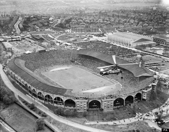
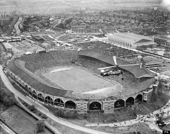
We can soar over London’s Wembley Stadium in 1924 and witness the first-ever boxing match held there, a sea of flat-capped men staring up at the ring. We can float over the banks of the River Clyde in 1936 and feel the immense pride and excitement as crowds watch the brand-new RMS Queen Mary—the grandest ship in the world—set off on her maiden voyage.
We can also witness moments of hardship. Photos from 1947 show the great Thames Flood, with entire London neighborhoods submerged under murky water, streets turned into canals. These images aren’t just historical records; they are deeply human documents. They show our resilience, our ambition, our vulnerability.
They show a Britain on the cusp of unimaginable change. A world with far fewer cars. A world where the scars of the first war were still fresh and the storm clouds of the second were gathering on the horizon. A world before the motorways carved up the countryside, before glass-and-steel skyscrapers dwarfed the old stone churches.
It’s a lost world. But thanks to this incredible project, it is not a forgotten one.
The hunt is far from over. Thousands of images still wait for an identity. They hang in the digital ether, waiting for the right person to see them. A person who can spot a familiar church spire, recognize the curve of a coastline, or remember the name of a factory long since demolished.
The clues are there, captured in a monochrome sky a century ago. All they need is a pair of eyes.
Your eyes.
What will you find?