The Blacked-Out Map: 4 Google Earth Secrets They Don’t Want You to See
Ever feel like you’re being watched? It’s an old, tired question. But what if the real question is… what are you being kept from seeing?
You pull up Google Earth. A perfect, digital globe spinning at your fingertips. You can zoom in on your own house, the pyramids of Giza, the deepest trenches of the ocean. It feels like total access. Complete knowledge.
But it’s a lie.
Across this meticulously crafted map of our world, there are holes. Black voids. Bizarre, pixelated smudges. Places that have been deliberately, and sometimes clumsily, erased from view. The official reasons are always bland. National security. Privacy. But when you look closer, the explanations fall apart, and a much darker picture begins to emerge.
These aren’t just glitches in the system. They are digital breadcrumbs leading to the world’s biggest secrets. Today, we’re pulling on those threads. We’re zooming in on the forbidden zones. Prepare to question everything you think you know about the map of your world.
The Bizarre Smudge Over Europe’s Space Hub
Our first stop is a place that, on the surface, has nothing to hide. Noordwijk, Netherlands. A quiet coastal town. But nestled within it is the European Space Research and Technology Centre (ESTEC). This is the technical heart of the European Space Agency (ESA). The brain. The place where Europe’s future in space is born.
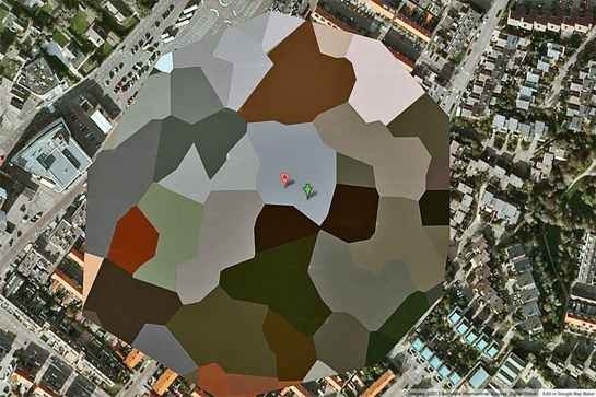
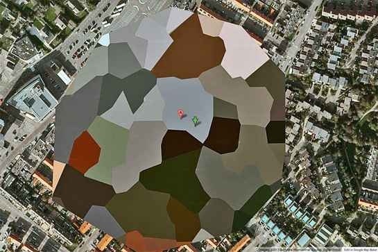
It’s a hub of innovation. It even has a visitor’s center. You can go there, take a tour, and marvel at models of satellites. So why, when you look it up on Google Maps, do you see this… a chaotic, almost artistic smear of green and brown pixels? It’s not a simple blur. It’s a deliberate, almost psychedelic pattern painted over the facility.
Why?
The official line is that it’s to protect sensitive technology. They’re building next-generation satellites, rovers, and components for rockets. Fair enough. You don’t want industrial spies getting a bird’s-eye view of your top-secret designs.
But does that really explain this bizarre censorship? Other, far more sensitive military installations around the world are simply blurred or pixelated with a standard filter. This looks different. Intentional. It draws the eye precisely because it’s so strange. A digital scream of “look away!”
Deep Dive: What’s Really Happening at ESTEC?
Theorists online have a different take. They ask a simple question: What if the technology being protected isn’t entirely… human?
ESTEC is where Europe’s best minds work on pushing the boundaries of space exploration. It’s where they analyze data from probes sent to the farthest reaches of our solar system. It’s where they process signals from deep space. What if one of those signals wasn’t just random noise? What if they received something? Or, even more chillingly, *recovered* something?
The bizarre, almost organic-looking pixelation has led some to speculate that it’s not just hiding buildings, but something far more unconventional. Could a facility this advanced be involved in reverse-engineering technology not of this world? A craft that doesn’t have the clean, straight lines of human engineering? Perhaps something that would look distinctly *alien* even from a satellite?
It sounds like science fiction. But then you remember, this is the European *Space Agency*. Their entire job is to deal with what’s out there. Hiding a groundbreaking, world-changing secret wouldn’t just be their job; it would be their duty. The strange digital camouflage over ESTEC might not be hiding a new satellite. It might be hiding a new reality.
The Alien Beacons of Baker Lake
Next, we journey far away from the polished labs of Europe to the stark, windswept tundra of northern Canada. Baker Lake, in the Nunavut territory. An incredibly remote place, home to the Inuit, and not much else. It’s one of the last true wildernesses on Earth.
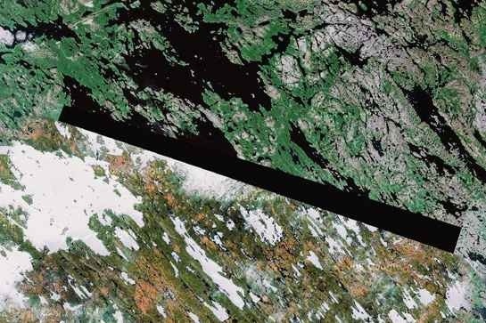
And on the map, it’s home to these.

Long, black bars. Perfect, unnatural rectangles censoring huge swaths of the empty landscape. They don’t correspond to any known military bases or government facilities. So what are they hiding out there in the frozen north?
According to one controversial researcher, a man identified as “Dr. Boylan,” these black bars aren’t hiding something human at all. He claims they are hiding extraterrestrial beacons.
Yes. Beacons. Placed on our planet by visitors from another world.
It’s a wild claim. A massive leap. But Boylan’s theory suggests these aren’t isolated incidents. He pointed to several other similarly blacked-out areas in other remote parts of the world, proposing they form a grid. A network. A system of alien markers, either guiding craft to our planet or monitoring us from afar.
What If He’s Right?
Let’s entertain the idea for a moment. Why here? Why Baker Lake? The region is close to the Earth’s magnetic north pole. If you were an advanced civilization looking to place navigational aids or energy-gathering devices on a planet, a location with powerful and unique magnetic properties would be an ideal spot. It’s the perfect place to hide in plain sight.
The Inuit people who have lived in this land for millennia have legends. Stories of strange lights in the sky, of “sky people” who would visit. Are these just myths, or are they the folk history of something real that has been happening for centuries?
Of course, there are other, more “grounded” explanations. Some suggest these areas could be related to secret diamond or uranium mining prospecting, with corporations requesting the censorship to protect their claims. Others say it’s simply a stitching error in the satellite imagery, a data glitch. But do glitches look like perfect, intentionally placed black rectangles? And if it’s just a mining claim, why the extreme secrecy, on a scale usually reserved for Area 51?
The beacons theory, as wild as it sounds, is the only one that seems to fit the sheer strangeness of the censorship. Someone, somewhere, decided that we absolutely cannot see what lies beneath those black bars in the Canadian wilderness.
The Siberian Void: A Glitch in the Matrix
If the Canadian censorship is surgical and precise, our next stop is the complete opposite. A clumsy, almost laughably bad cover-up in the heart of the largest, most desolate landmass on the planet: Siberia.
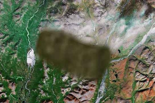
Fly over this remote region of Russia on Google Earth, and you’ll find it. A huge, blurred, smeared area where the landscape suddenly looks… wrong. It’s a jarring sight.

This isn’t subtle. It’s a hatchet job. Look closely, and you’ll see the truth. The area appears to have been crudely copied and pasted from another part of the map. The texture of the forest is repetitive. The lighting is off. It’s like a child tried to hide something in a photograph using Microsoft Paint.
This raises an even more pressing question than “what are they hiding?” It raises the question of “why hide it so badly?” A clumsy cover-up suggests urgency. It suggests something was hidden in a hurry.
A Land of Secrets
What could it be? The speculation runs rampant. Siberia has always been Russia’s dumping ground for secrets. During the Cold War, it was home to the gulags, to secret nuclear weapons facilities, to entire “closed cities” that didn’t appear on any official maps.
Could this be a modern version of that? A secret missile interceptor site, as one online commenter guessed? A new generation of radar station designed to watch the skies over the Arctic? It’s possible. The Russian military is notoriously secretive.
But the sheer sloppiness of the censorship has fueled more outlandish theories. Some have suggested it hides the crash site of a failed secret weapon test. Or perhaps a fallen satellite. Or something not of this world. Imagine a UFO crashing in the middle of nowhere. A frantic race to secure the site and then a rushed, digital command to “wipe it off the map, now!” That might explain the crude copy-paste job.
Whatever is there, it’s clear someone wants it to remain unseen. This blotch on the map of Siberia is a testament to the fact that even in our hyper-connected world, there are still vast zones of pure mystery, guarded by governments and hidden behind laughably bad digital curtains.
HAARP: The Weather Machine in the Alaskan Wilds
Finally, we come to the king of all map-based conspiracies. The legend. The facility blamed for everything from hurricanes to mind control. We’re talking about HAARP.
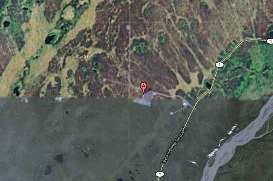
The High Frequency Active Auroral Research Program. Located in a remote patch of wilderness near Gakona, Alaska, it’s an eerie forest of 180 massive antennas pointing silently at the sky. And for years, the facility was a blurry, indistinct smudge on Google Maps.

The official story? HAARP is a scientific facility built to study the ionosphere—the upper, electrically charged layer of our atmosphere. By beaming powerful radio waves up into the sky, scientists can study the effects and learn more about this vital shield that protects us from solar radiation.
A harmless university project, they say. Nothing to see here.
But an army of conspiracy researchers, whistleblowers, and concerned citizens say that’s a lie. They claim HAARP isn’t just *studying* the atmosphere. It’s *controlling* it.
Deep Dive: Weapon, Weather Lord, or Mind Ray?
The theories about HAARP’s true purpose are terrifying. The central idea is that by heating and “lifting” parts of the ionosphere, one could potentially alter weather patterns on a global scale.
- Weather Warfare: Could HAARP be used to steer hurricanes toward enemy nations? Could it trigger droughts, floods, or even earthquakes by manipulating powerful jet streams or underground tectonic pressures? Theorists have linked HAARP’s activity to specific natural disasters, claiming they were manufactured events.
- Mind Control: This is where it gets even stranger. Some believe that the extremely low frequency (ELF) waves HAARP can generate could be used to influence human brainwaves. They speculate it could be a mass mind-control device, capable of inducing feelings of apathy, fear, or anxiety across an entire population. A tool for pacifying the public.
- A Global Weapon: Others see it as the ultimate weapon system. A device that could knock out all enemy satellites in an instant. A system that could disrupt global communications, bringing a country to its knees without firing a single bullet.
For decades, the U.S. Air Force ran the facility, which only added to the suspicion. In 2015, control was transferred to the University of Alaska Fairbanks, a move officials claimed was to focus on pure research. But for many, this was just a public relations stunt. A way to give a sinister military project a friendly, academic face while the real work continues behind the scenes.
While the Google Maps imagery of HAARP is clearer today than it once was, its legacy as a censored, forbidden zone remains. It stands as a powerful symbol of the public’s deep distrust of official narratives and the chilling possibility that humanity has built technologies far more powerful and dangerous than we are ever told.
The Map is Not The Territory
ESTEC. Baker Lake. Siberia. HAARP. Four locations, four mysteries, four black holes in our collective knowledge. These aren’t the only ones, not by a long shot. There are dozens more. Military bases in Greece, nuclear sites in France, entire islands that have been mysteriously wiped from the map.
Each pixelated smudge and blacked-out square is a question. Who makes the decision to erase a piece of our world from view? Is it Google, responding to government requests? Or do these orders come from somewhere else? A higher authority that operates in the shadows?
These digital curtains reveal a simple, unsettling truth: the world you see on your screen is not the real world. It is a curated, sanitized, and censored version of it. A version where the biggest secrets remain hidden in plain sight, disguised as a glitch or a blur.
So the next time you’re scrolling across that perfect digital globe, look closer. Hunt for the edges. Search for the blurs and the black voids. Because in those missing pieces, those carefully erased zones, that’s where the real story is. And it’s a story they never wanted you to find.